


Rando vélo Lac de Der

jeanmarcMasson
User GUIDE
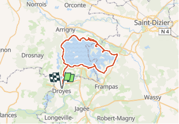

Length
56 km

Max alt
165 m

Uphill gradient
400 m
Km-Effort
61 km

Min alt
119 m

Downhill gradient
398 m
Boucle
Yes
Creation date :
2022-05-07 07:55:34.091
Updated on :
2022-05-07 15:50:36.685
4h31
Difficulty : Easy

FREE GPS app for hiking
 SityTrail
IGN / Geographical institutes
SityTrail Plus
The world is yours!
About
Trail Bicycle tourism of 56 km to be discovered at Grand Est, Haute-Marne, Rives Dervoises. This trail is proposed by jeanmarcMasson.
Positioning
Country:
France
Region :
Grand Est
Department/Province :
Haute-Marne
Municipality :
Rives Dervoises
Location:
Droyes
Start:(Dec)
Start:(UTM)
625500 ; 5375026 (31U) N.
Comments